Why Towns Gather Where Routes Cross
Why towns gather where routes cross depends on more than traffic: learn to read the crossing, its exchange, and the choices that shaped the settlement.
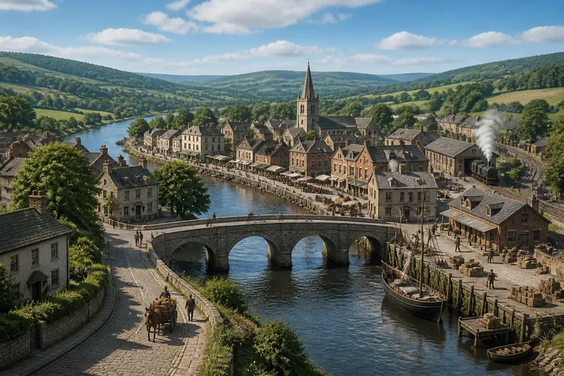
Why towns gather where routes cross is easiest to see at a bridge, ferry landing, or road junction where travelers must pause or choose a direction. Movement brings people into contact, but contact alone does not make a town. The useful question is what the crossing lets people do, and what happens after they do it.
Use the crossing as a starting point, not a complete explanation. A settlement may have grown around trade, lodging, transport, administration, or several of these at once. Its present shape also reflects later choices: where homes could be built, which route became dominant, and which side of an obstacle stayed accessible.
Start with the crossing
First decide what kind of routes meet. Two roads may converge because travelers are changing direction. A road and a river may meet because goods need to transfer between land and water. A bridge may gather movement at one narrow point, while a broad valley offers several possible paths and no single obvious center.
Ask what a traveler had to do at the site:
- Cross: A bridge, ford, ferry, or pass turns an obstacle into a point of concentrated movement. People and goods may wait, transfer, or seek help nearby.
- Choose: At a junction, travelers select among routes. Inns, shops, and services can benefit from people stopping to ask, rest, or change direction.
- Transfer: Where a road meets a wharf, station, or market route, cargo may change vehicle or handler. That creates work beyond simply passing through.
- Gather: Routes may lead to a market, civic center, or religious site. The destination can draw people even when the junction itself is not especially convenient.
These functions can overlap, but they are not interchangeable. A bridge crossing may channel movement tightly; a market junction may depend on people arriving from several directions on set days. A map can show where lines meet, but it cannot by itself tell you whether people had reason to stop.
Sort by the traveler’s need
If the crossing requires waiting, look for evidence of services tied to that pause. An inn, stable, ferry landing, or repair workshop may fit a place where passage was slow or uncertain. The settlement could serve travelers directly, or it could provide supplies and labor to those operating the crossing.
If routes meet but travelers can continue without stopping, a substantial town needs another draw. A market, administrative office, workshop district, or nearby source of employment may explain why people stayed. In this situation, the junction supports the town without necessarily being its main reason for existing.
If the routes connect producers with buyers, look for places where goods could be assembled, sorted, stored, or sold. A market square, warehouse area, or loading point may reveal that exchange mattered more than passenger traffic. Not every crossing becomes a trading center: the routes must connect people who have something to exchange, and the site must suit the transfer.
If a crossing is important only at particular times, expect a less steady pattern of activity. A seasonal ford, periodic market, or route used for a recurring local event may bring gatherings without producing continuous traffic. The absence of a large permanent center does not mean the meeting point was irrelevant.
Read the settlement’s shape
The crossing may explain a town’s first cluster, but later growth follows its own constraints. Look for a compact group of buildings near the crossing, then compare it with streets and neighborhoods farther away. A tight center can reflect limited space, concentrated services, or a route that forced people through one small area.
A street that follows a road out of the center may suggest growth along a continuing route. Several streets branching from a junction may point to separate destinations or later expansion. A square near the meeting point may indicate public or commercial use, but its presence is not proof that every nearby building served travelers.
Physical barriers can divide a place even when its routes converge. A steep bank, marshy ground, flood-prone area, or restricted bridge approach may keep development on one side. The crossing then gathers movement while the settlement spreads unevenly. A town can be a meeting point for travelers and a divided place for residents.
Later infrastructure can shift the center of gravity. A new bridge may bypass the old landing; a rail station may draw shops away from an earlier road junction; a road widened for through traffic may make a former stopping place less hospitable. The result can resemble a book whose pages were rearranged: the title remains, but the current order reflects later handling.
Choose the right explanation
Say you are examining an invented town called Millcross. Its old center stands beside a bridge where a rural road meets a river landing, while newer shops cluster near a station beyond the center. If the question is why the older settlement began there, the bridge and transfer between land and water are a plausible starting explanation. If the question is why current commerce favors the station, the later transport connection fits better. Neither answer explains every part of the town.
For a place you are trying to understand, use the explanation that matches the evidence and the question:
- Choose a crossing-centered explanation when the settlement’s earliest visible cluster sits at a necessary passage, and nearby services appear suited to waiting or crossing.
- Choose an exchange-centered explanation when markets, storage, or loading areas connect routes and local production more clearly than they serve passing travelers.
- Choose a destination-centered explanation when a civic, religious, industrial, or administrative place draws people to the junction, rather than the junction itself drawing them.
- Choose a later-growth explanation when the oldest center and the present commercial or residential pattern sit in different places.
These explanations can coexist. The discipline is to say which one accounts for which feature, rather than using “the routes crossed” as a universal answer.
What should you look for?
Does every junction become a town?
No. A junction matters more when people need to stop, transfer, trade, or reach a useful destination there. If routes meet without creating those needs, the crossing may remain a minor point in the landscape.
Why would a town form on one side?
Access to firm ground, water, a landing, or a safe approach can favor one side over another. Later land ownership, construction, and local decisions may reinforce that uneven pattern.
Can a bypass weaken an old center?
It can redirect through traffic and make a different location more convenient for transport or commerce. The older center may still serve residents or preserve civic functions, so a shift in movement does not automatically erase its importance.
How can I tell what the crossing was for?
Compare the route layout with visible features such as bridges, old market spaces, landings, station sites, and street patterns. Treat each clue as partial evidence, since a feature can outlast the activity that first gave it purpose.
Keep the claim local
A strong account names the routes, the obstacle or transfer point, and the activity that made stopping useful. It also separates the settlement’s initial attraction from the reasons it later expanded in one direction, lost business, or developed a new center.
That is the practical answer to why towns gather where routes cross: crossings can bring movement and exchange into contact, but people settle where that contact serves a need and where the site can support it. Read the crossing alongside the town’s shape, and the explanation becomes more precise without pretending that one junction designed the whole place.