The Boundary the Landscape Does Not Mark
Regional boundaries often have no visible mark on the ground. Learn to separate mapped lines from local ideas of where a region begins and ends.
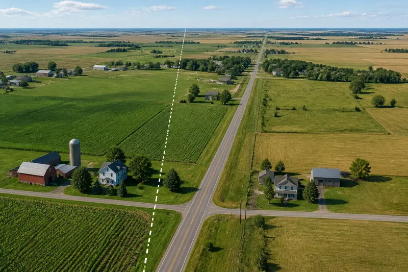
A regional boundary can cross a level field without changing the view. On a map, the line is exact; on the ground, the grass, road, and houses continue as before. The boundary the landscape does not mark is not necessarily a mistake. It may be an administrative edge, a customary limit, or a line people recognize for reasons that have little to do with terrain.
To understand such an edge, separate three questions: where a boundary is drawn, how it came to be drawn, and where people think the region ends. Those answers may overlap, but they need not. Consider an invented case: the fictional district of Bellwether, where a county line cuts through an agricultural plain. Following the line from map to lived experience shows why “the natural border” is often less natural than it sounds.
The map’s exact line
Bellwether appears on a regional map as a single colored area. Its eastern edge follows a straight line across the plain, then crosses a paved road and divides two neighboring communities. The map makes the boundary look settled and singular. It does not show whether the line follows a legal jurisdiction, a service area, an older division, or a shared local understanding.
Maps need edges because they sort information. A county map may distinguish jurisdictions; a tourism map may group places by visitor services; a school district map may show where responsibility changes. Each line answers a particular question. The same place can fall within one region for one purpose and another for a different one.
Scale matters, too. A small-scale map simplifies bends and minor features. A detailed cadastral map may show a boundary in relation to parcels, while a general regional map may display only a neat stroke. The stroke is a symbol for a line, not a physical fence. Treating it as a visible feature confuses the map’s precision with the landscape’s appearance.
In Bellwether, the county line is legally identifiable, but no sign marks it on the field road. A person driving through might see no change at all. A resident checking a permit, tax notice, or service map might encounter the boundary immediately. The line is invisible in one setting and consequential in another.
Why terrain misleads
Physical features can make convincing boundaries. A ridge, river, marsh, or abrupt change in soil may separate places in practical ways. But a feature that looks like an obvious edge does not automatically define a region. A river may run through the middle of a shared settlement; a ridge may be crossed daily; a plain may have no discernible break at all.
Bellwether’s county line crosses open farmland rather than following the nearby creek. Someone arriving with the expectation that borders track rivers might assume the creek marks the edge. Yet the county line lies several miles away. The creek matters for drainage and land use; it does not determine this jurisdiction.
Even when a boundary follows a physical feature, people can interpret the feature differently. A river has two banks, bends, channels, bridges, and crossing points. A map may trace one channel, while residents think of both banks as part of the same town. Like a seam in a plain coat, a mapped boundary can be real without changing the fabric around it.
Terrain also changes in significance with how people move through it. A steep slope may be a serious barrier to a farm vehicle and a minor inconvenience to a hiker using a trail. A broad river may divide administrative responsibilities while a bridge makes the neighboring town part of everyday life. The land constrains some choices; it does not dictate one shared regional edge.
Three competing edges
In Bellwether, three boundaries can be drawn, each useful for a different question. The county line identifies jurisdiction. A local service area identifies which office handles waste collection. Residents’ accounts describe where they feel Bellwether begins. The last edge may be less tidy, but it is not less meaningful simply because it cannot be entered as one official coordinate.
The service area follows a route used by collection trucks and excludes a few properties that lie inside the county. A resident may belong to Bellwether by county records but rely on another town’s clinic, market, or bus stop. Someone else may say the neighboring town is part of Bellwether’s orbit because work, school, and social visits link the places. These are not necessarily competing claims to the same kind of boundary.
Local identity often works through association rather than a continuous perimeter. People may name a valley, a cluster of villages, or a stretch of road as one region, even when its edges are vague. The region can remain clear in conversation: residents know which places belong in the description, while disagreeing about an outlying farm. That uncertainty is information, not a cartographic defect.
Visitors may use a different edge again. A visitor’s idea of Bellwether could stop at the sign on the highway, while residents include farms beyond it. A sign is a public cue, not proof that everyone shares its boundary. It can announce a municipality, a commercial district, or a local brand, depending on who placed it and why.
Following the invented case
Say you are asked to explain whether a farm on Bellwether’s eastern edge belongs to the region. The starting point is a parcel beside the county line, with no change in terrain and no roadside marker. The question sounds simple only until “belongs” is specified.
First, identify the decision at hand. If the question concerns county administration, consult the relevant official map or records. If it concerns waste collection, look for the service-area boundary. If it concerns a regional identity project, ask how residents describe the place and what connections shape that description. One question should not be made to answer for all three.
Next, compare sources without forcing them to agree. The county map places the farm in Bellwether. A service map puts it outside the collection route. A fictional resident, Mara, calls the farm “out past Bellwether” because she shops in the neighboring town, while her neighbor describes it as part of Bellwether because the children attend a local school. Both accounts reveal patterns of connection; neither silently replaces the jurisdictional line.
Then record the result in language suited to the claim. For an administrative note, say the farm is inside the county boundary but outside the service area. For a description of regional identity, explain that local usage varies and name the connections people cite. Avoid writing “the boundary runs along the creek” unless a reliable map or record shows that it does.
The expected result is not one master line. It is a clearer account: the county edge is fixed for that administrative purpose, service responsibility differs, and the farm’s cultural association is disputed or mixed. This is a usable answer, not a failure to choose. It tells readers what the boundary means before asking them to accept where it lies.
Questions about regional boundaries?
Does every region have a clear edge?
No. Some regions have legally defined boundaries, while others are understood through shared speech, services, landscape, or everyday connections. Their edges may be gradual or contested rather than a single line.
Can a river define a regional border?
It can, if the boundary is formally or conventionally tied to it. But a river’s presence alone does not establish that role, and residents on both banks may experience one connected region.
Which boundary should a map show?
That depends on the map’s purpose. A jurisdiction map should show the relevant official edge; a map of local identity should explain how its area was defined and where accounts differ.
What if residents disagree?
Describe the disagreement and the reasons behind it rather than smoothing it into false consensus. Different accounts can point to different kinds of belonging, not merely different opinions about one line.
Reading the edge carefully
A careful account names its boundary type. “County boundary,” “service area,” and “local region” are more useful than an unexplained “border.” It also identifies the source behind a mapped claim and distinguishes that source from residents’ descriptions. If a boundary matters for a formal decision, check the relevant records; local rules and official definitions can differ.
For regional writing, the point is not to make every edge vague. Some boundaries are precise and consequential. The point is to avoid giving a physical feature authority it has not earned, or presenting an administrative line as a complete account of belonging.
The boundary the landscape does not mark becomes easier to understand once its purpose is named. In Bellwether, the county line, service limit, and remembered region each answer a different question. When describing another place, state which edge you mean, then show how people encounter it. That small distinction can keep a clean map from telling a messy, and less useful, story.